A Discontinuous Walk in Beirut
Connectivity and Edge-Connectivity / EURAU’12
ABSTRACT. Beirut public domain is permanently disrupted by physical obstacles along the walk. It is the reflection of a city with multiple scars. To insure a sustainable living for this city going into the future, the public space network work to heal the city and reconnect the boundaries.
KEYWORDS. Connectivity Walkability Urbanity Gathering Peace
Beirut has an exceptional location on the Mediterranean: Beautiful green steep mountains and long beaches. Yet a very small country. Surrounded by bigger states. Envied for its natural resources and its beauty. A population of sailors and merchants, searching for culture, wealth and prosperity. Lebanon is burdened and blessed by 17 recognized religious sects. They make both its diversity and unique way of living, and its potential instability. Lebanon’s history is unique. Several interventions, colonization in such a tiny area and in such dense period of time: The Phoenicians, the Arabs, the Ottomans, the French. And then at Lebanon’s peak in 1975, when it began to qualify internationally as the Swiss of the Middle East, comes the civil war. Length: 15 years. Everything foresees Beirut to be an attractive city: rich layers of history, different urbanization and urban settings combined with beautiful nature. There we stopped. Because of the proximity of the sea and the mountains, Beirut thought it was needless of public spaces, more accurately green public spaces. We took for granted that a 15 minute ride to the mountains and 5 minute ride to the sea is sufficient for any city to be happy. We forgot expansion, we forgot traffic, and we forgot urban living at every level of the city. We forgot to plan.

Fig.1
Here we are in 2012: Beirut a city of concrete. The current status of Beirut is due to endless reasons, none justifiable. I am going to quickly summarize the drawbacks of a country that took years to get there. Weak government authority with lack of budget and some thievery, sectarian leaders tending only to their own territory without an eye on the overall picture, civil war, greed and short slightness of individual owners breaking the city scale in every plot. The disruption of Beirut as livable city was dismantled both at the macro and micro scale. No master plan to guide the strategic development of the city and individuals taking advantage of it to their own interests leaving no room for any generosity. No public domain. I believe that’s what urban planning does: ensure the rights of every citizen to be integrated in a harmonious vision of a city. Beirut at a point in time, during the civil war, lost
track of its huge potential as a city for the future and declined into an assemblage of mid to high rise buildings on a so-called grid of roads. Beirut is not small. In scale it can be compared to Paris intra-muros.

Fig.2 Beirut versus Paris
There was no official census for the Lebanese population since 1932, but statistics made in July 2010 estimates the Lebanese population at 4.2 Millions, Beirut itself ranges between 1 Million (low) and 2 Million as high, meaning between 1⁄4 to 1⁄2 of the total population of country. Huge percentage, meaning huge needs for amenities: Urgent need for planning. What are Beirut’s/Lebanon’s most essential needs? One would always start with the elementary necessity: Infrastructure. Infrastructure is electricity, water system, sewage system, road network and adequate affordable housing. For Beirut particularly and Lebanon generally, here’s what we do. We pollute the sea with our waste and sewage, we infest our air with CO2 due to individual generators that almost every house in Beirut has because of the shortage of state electricity, we fill our tank with water for 6 months a year despite being envied by all our neighbors for our water resources and we build savagely on our mountains while our city center is empty. Our urban highways are off-roads in areas where the sellable m is at 4000$ (totally unaffordable for 4/5 of the population) and where one can easily smash his car all year long. Knowing all that, does one still really care about public green parks, squares, sidewalks and fountains? Isn’t this whole green urban awareness too luxurious for our own needs? No. Public domain and public space is what citizens’ share as part of their beloved city: common ground. It is the encounter where the social dialogue really happens. It is the life and the vibrancy that underlies the city grid. It is the soul that shapes the physical forms surrounding us. It is the reason why we live together in urban area and why we love it. The interaction and the collision. In Beirut, more than any other city in the world, sectarianism is at every door. Beirut is divided in sectors and every sector has its own sectarian color. People from different areas barely mix: they live so close and yet so far from one another. The social pattern extends to the physical/urban one, or is it the opposite? I believe, the social introversion is the unconscious phenomena that make us unable to have a proper walk in Beirut. Discontinuity: Discontinuity in the public domain, discontinuity in the common belief. We do not intersect. In mathematics and computer science, connectivity is one of the basic concepts of graph theory. The connectivity of a graph is an important measure of its robustness as a network. In 1927 Karl Menger’s theorem talks about connectivity and edge-connectivity, later it will become the max-flow min-cut theorem. As an urban designer and a Beirut resident,
I propose edge-connectivity to save Beirut public space and by doing, that allow Beirut to work as a sustainable contemporary city. The suggestion is: create or reinforce the public spaces at the edge of the different sectors. Invest in the areas of intersections between different quarters and turn them into communal spaces (parks/ squares/ libraries...). Beirut in terms of scale is a walkable city and in climatic terms, it is a city that can easily be enjoyable. The impossibility of having a real walk in it in its current condition is because of distinct boundaries between sectors. Most of these barriers are physical; they create the sense of unwelcomeness from sector to sector. Motorways separate different areas: they cut the urban streetscape and the human scale connectivity and make the city Car Land. These types of roads are citie’s worst enemies. They should become boulevards where pedestrians can cross safely between rows of trees. Achrafieh, Bachoura, Mazraa, Minet el Hosn, Moussaitbeth, Ras Beirut, Rmeil, Saifi, Zouqaq el Blat etc coexist in 30km , each of them has a certain set of public spaces scattered around the place but they hardly interact and they do not share public spaces at the city scale. The plan shown in Fig.3 will take Beirut edges and specificities and turn them into the Beirut public space network. What used to separate the city is now its main interaction points.
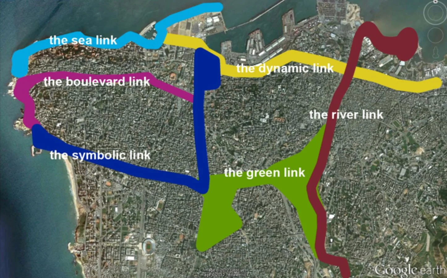
Fig.3 Beirut six edge-connectivities
The six proposed edge-connectivities are: the sea link, the boulevard link, the symbolic link, the dynamic link, the river link and the green link. The sea link is the pedestrian connectivity that goes from the new Beirut waterfront to the historical “Beirut corniche” passing by the newly inaugurated “Zaintunay Bay” (restaurants and shops along a pedestrian deck and a marina) and leads to the beach resorts area. The Boulevard link starts along the Charles Malek avenue passing over Beirut’s downtown into Spears street onto the General de Gaulle boulevard onto the “Beirut corniche” and ends majestically on the Raouche Park (a current no man’s land belonging to the State). The Symbolic link starts from the heart (which is actually the edge) of downtown Beirut “the Martyrs’ square” (square that has hosted Lebanese history: manifestations for independence, public executions and the famous “one Million” person demonstration in 2006 when the Syrians withdrew their army from the country) continues along the Bechara el Khoury avenue, intersects at the “Hippodrome” and turns perpendicularly onto the Saeb Salam avenue ( edge of the southern suburb that should absolutely be integrated as an important component of the city, both socially and physically)and rejoin the General de Gaulle boulevard to close the public space loop proposed. The dynamic link is what use to be the railway; it incorporates the non-used main station and the huge park belonging to it and the public buses parking and cemetery property of the state. The link will continue directly to reach the downtown and the Beirut souks. This link is totally none existent now. But its potential to connect the eastern suburbs to the city by a public transport routing and from there to connect it to the overall public space loop is a critical dimension to the city cohesion. The river link should become what cities like London and Paris have built around their riverside: a vibrant hub of entertainment, main touristic features and public spaces. Instead it is now the left over space of the industrial area. This link ought to become the main city leisure activities area filled with vibrant public squares where bicycles and pedestrians juggle happily along. The river goes down to the sea. Next to it to the east, there’s the Quarantina garbage mountain. It can be treated and transformed (a study has already been made) into a Park or even a business park to maintain its economic feasibility. Last but not least the green link. The green link, strangely enough already exists as a green public space. But it’s not opened to the public. One of Beirut’s oldest and most beautiful parks, reminiscent of a Phoenician forest is the “Horch el Sanawbar” or “Bois des pins”. It was closed to the public in 1995 to protect it from uncivilized behavior. Reopening this 0.63km green area in the middle of the city and linking it with the wastelands of the industrial zone next to the Beirut River will create a perfect connection that links and join the loop of public space network that I am proposing. The “Horch el Sanawbar” will have to be protected in a much more civilized way than by closing it: Maybe informal surveillance, maybe civic awareness courses in schools and universities, public campaigns to enhance the environmental consciousness of the Lebanese population. Other methods could work too: allowing to the residents to participate in the maintenance of the park or even better, let them plant new trees, making them feel part of a project that they would be proud of. Bringing people to care is the only way forward to a sustainable green future for us all. Several campaigns based on private initiatives have already tried to give the Horch back to the city.

Fig.4 Posters for the “Horch al Sanawbar” public opening
The last topic I want to raise for a public space strategy in line with the connectivity theme is the hierarchy of public spaces at different scales of the city. Public space is not a single solution problem that can be resolve at once. It is a multi-scale, multi- purpose and interactive response to an urban context depending on its density, land use and its natural mutation. Public spaces should exist in our cities at every level of it: city-scale, sector-scale, neighborhood-scale, and street-scale. A city-scale public space should allow for big events, huge gathering and have a large beneficial impact on the city, like the “Martyr square” and the “Horch Beirut”. One is still a void in-between two sectors and the other one is closed. We have the “Beirut corniche” that currently functions at that level. Sector-scale public spaces are smaller spaces but they are more divers to accommodate a larger set of the community’s needs. Jnaynet el Sanayeh, even being very badly maintained (fountain removed from its water, asphalt instead of paving etc) is a good example. We have to notice that most of the other sectors do not benefit from this type of luxury. Neighborhoods-scale public spaces are the parks where one can send his children for a breath of fresh air and a small injury on the knee. In Achrafieh, we can find the Jnaynet el Sioufi in the Neighborhood of Sioufi but even there we can watch the slow insignificance of the place due to the increase of density that comes with the rise of towers in the area and the total negligence of its maintenance in it. Street-scale public space: At the stage where Beirut present itself as a urban friendly city, I think one must omit to talk about the street scale public space. It is a far too ambitious project. In Tokyo for example, where we can find a Pocket parks in every street, in Buenos Aires, sidewalks are enlarged to be able to have some integrated green areas. I want to conclude by Frank Lloyd Wright quote:
“Nature is the only face of God we will ever see”. Therefore we should allow nature to invade our cities and Beirut specially to upgrade our quality of life and to compensate the increasingly high density that we are accommodating now and will in the future. In 2008, half of the world population became citizens, in 2030, we will be 5 billion. It is very crucial that we find solutions and ways to make our cities the best they can be: Public transport, affordable and adequate housing, public spaces and greenery.
Bibliography
AELBRECHT, Patricia Simoes. Rethinking Urban design for a changing public life. LARKIN, Craig. Reconstructing and Deconstructing Beirut: Space, Memory and Lebanese Youth. Exeter, 2009 OELLERMANN, Ortrud. Menger’s Theorem SHAYYA, Fadi.S. Enacting public space/ History and social practice of Beirut’s Horch el Sanawbar. Beirut, 2006.